Health & Fitness
Mendota Trail
I wrote this article on the 6-mile Mendota Bike Trail for the Lilydale Spring Newsletter, for my column called Lilydale Explorer.


On the first warm day of the season, even though the grass had not yet turned green, I had to get out of the condo and explore.
I chose a bike route that one can almost never explore in the early spring because it always floods in this area. This is the Mendota Trail, a dirt trail that goes from Mendota to the Hwy. 77 Bridge along the Minnesota River.
I chose to start at the 77 Bridge end, and to avoid having to bike 8 miles on the highway, I asked my friend, Dick Henke, to take me there in his car. But if you wanted to make a loop of it you could bike there on Hwy. 13 (there are wide shoulders) and go 3 mi. past 494 to Silver Bell Rd. toward the Minn. River, then after about a half mile, turn right (North) on to Nichols Rd. which parallels MN 77 and go down to the Jens Caspersen boat landing which is where the trailhead starts beneath the 77 bridge.
Find out what's happening in Mendota Heightswith free, real-time updates from Patch.
All of this area is actually within Fort Snelling State Park. A second way to do this loop on your bike, from Lilydale, would be to take the west to the Pilot Knob Lookout (it looks out onto Gun Club Lake and the Minnesota River Valley) and on to 494 where the Big Rivers Trail ends. Then get on the wide shoulders of Hwy. 13 and go to Silver Bell Rd. and follow as directed above. My guide on this trip was a 2011 Official Dakota County Parks and Bikeways Map which is available free at City Hall or online: www.co.dakota.mn.us.
I was ready for an adventure and knew this trail was kind of “wild” because it was only a dirt path. During the winter I had read a couple of adventure books, both of which I highly recommend, that got me fired up to have an adventure of my own.
Find out what's happening in Mendota Heightswith free, real-time updates from Patch.
One was Canoeing with the Cree, written in 1930, by Eric Sevareid at the young age of 17, when he, along with a friend, took a canoe all the way from Ft. Snelling on the Mississippi River north to Hudson Bay. If you want a good book and an easy read, I definitely recommend it along with the other adventure book I read called Paddle to the Amazon by a Canadian (Don Starkell) who along with his son canoed all the way from Winnipeg to the mouth of the Amazon. Can you imagine?! –a 12,000 mile trip in a canoe! An incredible story that I encourage you to read!
My own small adventure started and ended on St. Patrick’s Day. It was a partially cloudy day with temperatures in the mid-seventies and humid. There were no leaves and no green anywhere, but ordinarily this is a mostly shaded trail with nice river views. In some places it is wide enough for a pickup truck and some places tend to get washed out. It is mostly compacted dirt with some sandy areas that make it slow going. I rode in low gear the whole way even though there is very little up and down.
It also was muddy in a couple areas, but word to the wise, if you ever come to a point on a trail where you find a 3 foot wide and deep crack in the earth like I did, and see water everywhere around and no way to get across the gulley, or so you think, do not attempt to walk around it. It is better to simply get your feet wet and walk through the gulley rather than going around as I did. I, along with my bike, got sucked into the mud --to ankle and bike-spoke depth. It reminded me exactly of what happened in one of the chapters in Canoeing with the Cree, called Red River Mud. I’m sure you can picture it.
Once past this area it was easy going. I stopped to take photos at many of the lovely marshy lake areas on the south side of the trail. What first got my attention to the beauty of the spot was a mother goose sitting, oh so upright, on her nest. There was much evidence of beavers at work as well. I also stood on the foundation of an old dam which is used to control the water level of Gun Club Lake. I used the water here to wash off my dirty shoes and ankles. I biked on and found a place for lunch well past the 494 bridge – beside an upturned totally rusted out car from the early 50’s, I thought. I wondered how it ended up here.
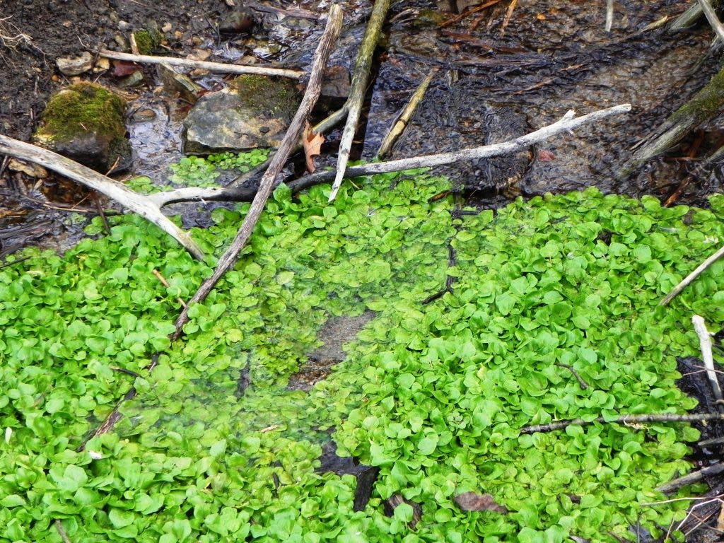
There was also the foundation of a house with a fireplace and I marveled at how the occupants could stand the floods each year. Many of the trees showed flood lines at the 4-6 foot level. I continued on, and once past the Mendota Bridge, I came upon a huge patch of watercress in a little stream, the color of a perfect St. Patrick’s shamrock, and the only green I saw on my trip. I picked a couple big clumps of it and stuffed it in a plastic bag I had from my lunch. Later, I found a recipe online for “Thai grilled salmon with a watercress, mint, and garlic-chili-ginger sauce” and plan to make it soon because watercress does not stay fresh for long.
This is a lovely secret spot to know about where I can come and forage for watercress every winter. Watercress is brimming with vitamins and minerals, so it’s a great food to have in your cooking repertoire. I’ll be back here in a few days to get more, and next time I can walk this far on the path by parking at the trailhead in Mendota.
Around 1:30 PM I reached Mendota. I walked through the tunnel under the railroad bridge and came out at the . Here I spent some time reading all the informational display signs and also saw something completely new in the way of informational signs that I had never seen before.
On a wooden post there was a small sign labeled “Cell phone tour” with a phone number to call on your cell phone, of course. So I did, and plugged in the number given for the Sibley site. I later found out by looking online that these are located at different Twin Cities sites, such as Ft. Snelling, the Capitol Mall, and the State Fair, placed there by the Minnesota Historical Society, for people to learn “History on the Spot”. Just by dialing the number (of course you use up minutes on your cell phone), I learned that the Sibley Historic site was the first official historic site in Minnesota and was established here in 1910. At the Dupuis House on the extreme SE corner of the property (on the main drag through Mendota), by calling the number on the display, I learned that in 1928 the house was remodeled for a tea house and eventually became one of Minnesota’s most popular tea houses serving thousands of guests each season until it closed in the Seventies. It now houses the offices of the Sibley Historic site.
How could I have known this so easily and quickly without using this cell phone tour? Later, I learned more by going online and finding a schedule of upcoming events for this historic site. The opening weekend of the Sibley Historic Site where one can take tours, is May 26th and 27th. One can also call the History on the Spot phone number, 877-411-4123, any time -- in your car or from your home.
I was getting pretty tired and was ready to bike on, but then a family approached me and asked me if there was another bike trail that follows the Mississippi River nearby. I was able to answer their question with some authority about the subject. I said “Oh, yes, you just bike east through the little town we’re in – Mendota – and at the other end of town, you will come to the paved Big Rivers Regional Trail on your left. It parallels and has great views of the Mississippi River and signs to tell you some history. It ends up at the Pool and Yacht Club on the River which you can go around on your bikes and get on the Lilydale Regional Park trail which takes you further east to Harriet Island Regional Park and on into St. Paul.” They said, “St. Paul is where we want to go!” So what a perfect trip they made that day, just like me, and I was able to help them find their way!
I then walked my bike across D St. from the DuPuis house and paused a moment in the parking lot of what used to be the Hall Brothers Emporium of Jazz Restaurant which went out of business in 1991. I can’t tell you how many times, in the late eighties, my ex-husband and I drove up to the Twin Cities from Rochester just to go to this establishment, mainly for their food, since we were “foodies”. Our favorite thing on the menu was their Red Beans and Rice. And now I ask myself how, out of the blue, did I end up in the little town of Lilydale right next to Mendota, both with all their interesting history? I could never have imagined that my future would hold this in store for me. The Sibley Historic Site helps anchor us to a past we never directly participated in, but the Emporium of Jazz, for me anyway, helps anchor me to my own past. And so the value of memories! And may there be many more in this new place I call home.